|
|||||||||||
|
|||||||||||

 |
|||||||||||
 |
 |
 |
|
|
|
|
|
|
|
|
|
|
|
|
|
|
|
|
|
|
|
|
|
|
|
|
|
|
|
|
|
|
|
|
|
|
|
|
|
|
|
|
|
|
|
|
|
|
|
|
|
|
|
|
|
|
|
|
|
|
|
|
|
|
|
|
|
|
|
|
|
|
|
|
|
|
 |
|
List of Figures
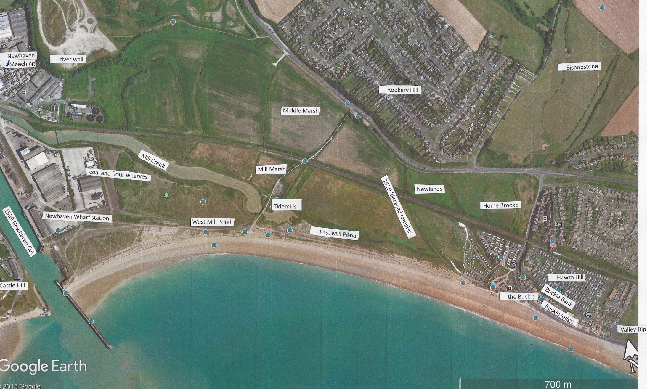
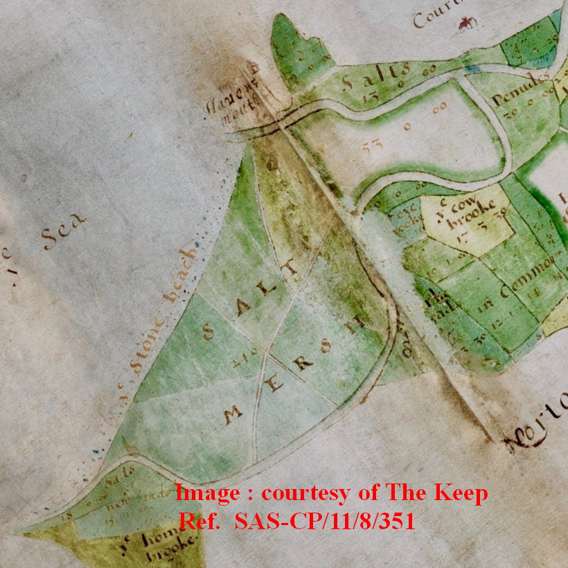
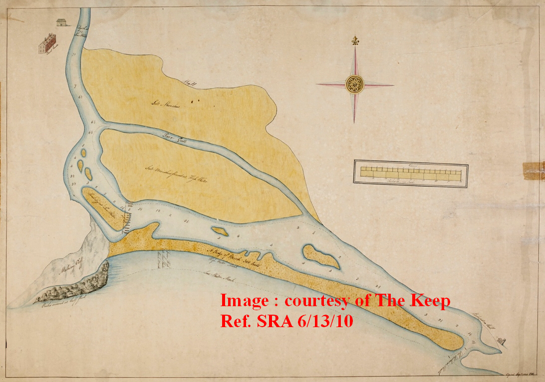
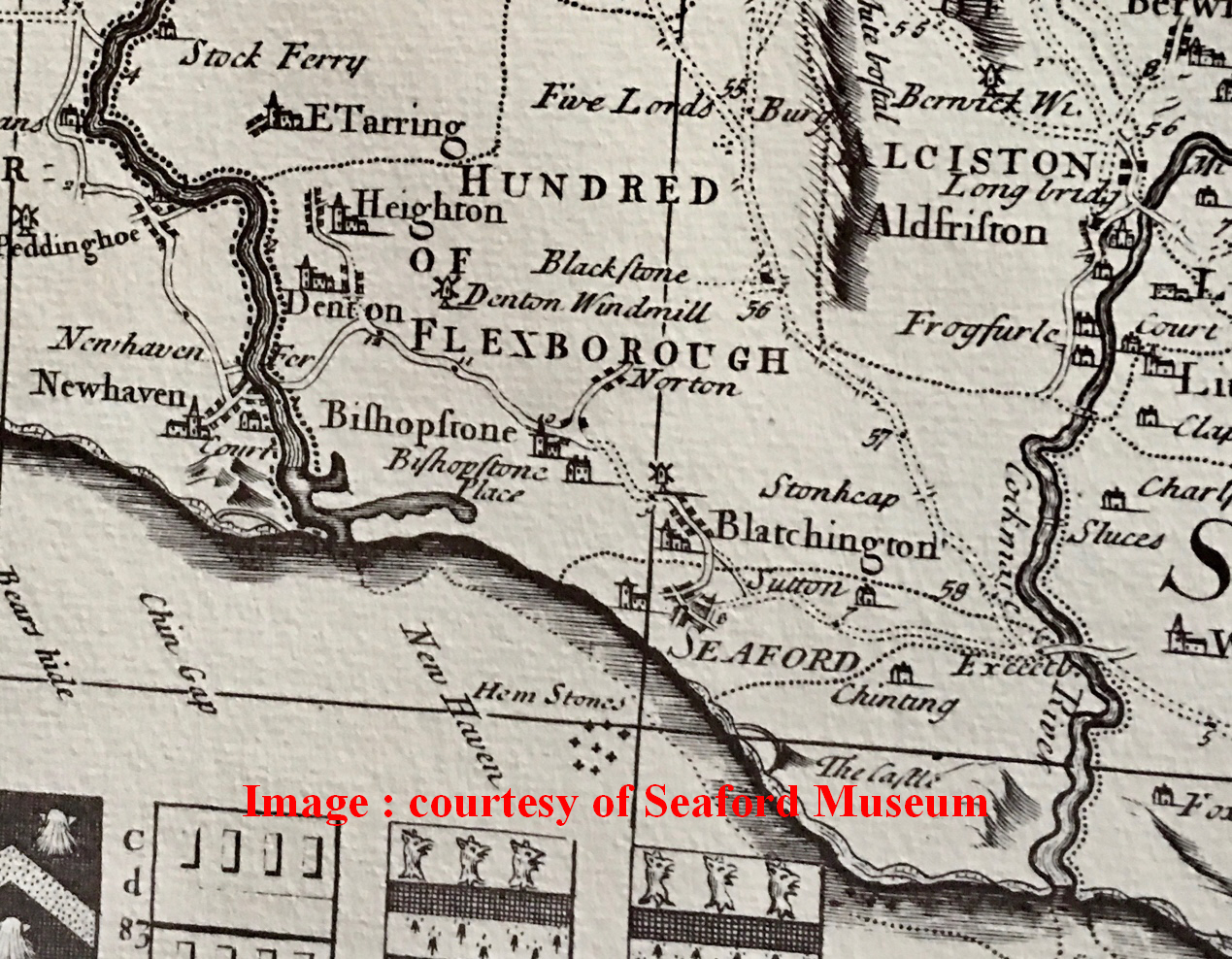
BISHOPSTONE TIDEMILLS AND ITS IMPACT ON LANDSCAPE 1. Introduction. Although there are already several accounts of this significant industrial establishment (Farrant S. , 1975), (Lyndhurst, 2001, revised 2008), (Vince, 2015), recent information arising from the extensive but as yet, incomplete excavations carried out under Luke Barber of the Sussex Archaeological Society, and the collation of further cartographic research, has made it possible to fill in more details about Tidemills. This, when reviewed against contemporary surveys, and brought together with archaeological findings, sheds further light on this important local enterprise. The cartographic record is remarkable, starting with John de Ward's magnificent survey of the Ouse in 1620, (Fig 2) using basic surveying tools such as the Gunter's chain and ranging rods, John de Ward achieved an accuracy of +/- 30m for this part of the estuary (see Fig 25). (Uwe Dornbusch, 2018). Given 400 years of mobility of the Ouse channels described later in this paper, this is acceptable as an assessment of accuracy. Using this as the starting point, and Thomas Marchant's 1777 survey (Fig 6), it has been possible to interpret intervening surveys which have a lesser degree of accuracy. By comparing them to the accurate OS series of maps from 1861 and with what can be seen on the ground today, I have been able to reach the conclusions in this paper that show the powerful impact the Tidemills venture had on the present landscape, by calming what I call "the restless estuary". Almost all of the illustrations are available as higher resolution images at Seaford Museum. I have omitted the impact on the beach profile of the various breakwater works at Newhaven Harbour since the 1880s, to focus on Tidemills itself. 2. Historical background to "the restless estuary" 1422-1761 In the spring of 1422, the responsibility for managing the lower Ouse was placed by Henry V on the Commissioners for Sewers. In 1539 they commissioned the Newhaven "cut" from Meeching to Castle Hill. Following this "cut", the mobility of the shingle between Castle Hill and Hawth Hill caused the Commissioners for Sewers to re-cut it after a great storm of 1579 destroyed the shingle beach. In 1620 the Commissioners appointed John de Ward to survey the entire lower Ouse valley from the sea up to the Lewes and Laughton Levels. (Fig 2). This remarkably accurate document (as referred to in the introduction) captures the lower Ouse when it had 2 exits, one at the 1539 "cut" and the other in its earlier position, exiting to the sea at the foot of Hawth Hill. It shows the area as tidal salt marsh, criss-crossed by footpaths and separated from the sea by a "stone beach". The survey helped the Commissioners to carry out improvements to the land drainage of the valley and fairly allocate costs to landowners by means of field acreages. The salt marsh is shown as a tract of 240 acres in single ownership, as distinct from adjoining fields which are much smaller, and in the hands of many and diverse owners, reflecting their greater agricultural value. Where the Ouse met the side of Hawth Hill, its route was constrained by an embankment that separates the river from 2 fields, (Newlands and Home Brooke), stretching from Rookery Hill towards the Buckle. The embankment protected the Bishopstone valley from marine incursions and was probably built following the creation of the 1539 "cut", to take advantage of the opportunity for draining this part of the saltmarsh. The embanking material was probably cut from the quarry which was on the side of Rookery Hill beside the present A259 (Figs. 1&2). This embankment was mis-identified as "a decayed rampier" (a military rampart), by Sir Thomas Palmer & Walter Covert in their 1587 survey (Farrant J. H., 1972, p. p44). A second embankment is also shown in this survey, running from Newhaven's Court House Farm at the point where the Ouse splits into 2 channels. It protects a field called "Penudes" and other fields to the north from marine incursions. Both these features exist today and so have clearly achieved their purpose. (Farrant J. H., 1972, p. p46). However, powerful marine forces continued to work at the beach, with onshore and longshore drift of shingle continually changing the natural exit of the Ouse. The 1539 cut had to be re-opened again in 1633, in 1645, in 1647-8, in 1660, and again in the mid 1690s.
Land reclamation known as "inning" had taken place along the Ouse from the sea to Lewes, Glynde and beyond, and generally, with success, upstream of Newhaven. (Brandon, 1971, pp.99-100) In 1700 the Admiralty commissioned a scaled survey drawn to a defined scale so distances can be calculated (Fig. 4). The river wall that protected Penudes appears as the northern boundary of the Parr Gutt saltmarsh, the "cut" still blocked and the mouth of the Ouse is about 610m west of the Old Buckle, i.e. close to Tidemills.
Lt. William Roy and David Dundas were commissioned in 1756 to carry out a military survey of the Channel coast from Dover to Milford Haven. Great Britain was in the middle of the Seven Years' War with the French (1756-1763), which therefore made this stretch of coastline vulnerable to invasion. The surveyors were repeating the work carried out along the Sussex coast by Sir Thomas Palmer & Walter Covert in 1587, prior to the Spanish Armada. The first part of the 1756 survey (8 sheets covering the Sussex coastline) was published on 1 February 1757 (Fig 5). The whole commission was not completed, as the threat of invasion was diminished significantly following the Royal Navy's significant defeat of the French Navy at the Battle of Quiberon Bay (off St Nazaire) on 1 November 1759. Roy and Dundas' survey depicts the Ouse estuary, just before Tidemills was constructed. Although Roy was responsible for the magnificent feat of mapping the Scottish Highlands between 1747-55, and became generally recognised as the founder of the Ordnance Survey, his 1756 survey reflects the speed of production and should be viewed in this light, as it contains several inaccuracies. Based upon earlier surveys he exaggerates the width of the beach in front of Hawth Hill, inserting a road that would have been impracticable on such a shingle beach. It places Seaford on The Salts, and also gets the town's street pattern and orientation completely wrong. It misses out the road from Bishopstone to Blatchington, gets the Seaford to Exceat road wrong, all of which would be useful intelligence from a military, strategic point of view. However, it is a remarkable document in its entirety and is the best depiction of the area just prior to the Tidemill enterprise began. It illustrates clearly the very braided nature of the Ouse below Newhaven, with the Ouse emerging beside Castle Hill, and a long tributary running behind the shingle beach towards Hawth Hill and Valley Dip (see Fig. 1 for locations). In this context, a major re-engineering of the landscape through the construction of the Tidemills infrastructure would also bring significant land reclamation benefits. In the Bill presented to Parliament in 1761, the area is described as "a Piece of Saltmarsh, or Waste Ground, covered with Water at the Time of High Tides, lying within the Manor and Parish of Bishopston" (Commons, 1762). This accords with the 1757 survey (Fig.5).
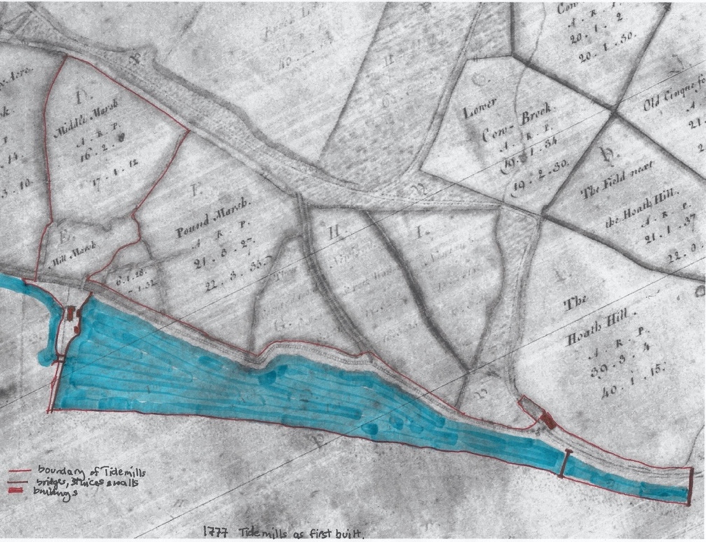
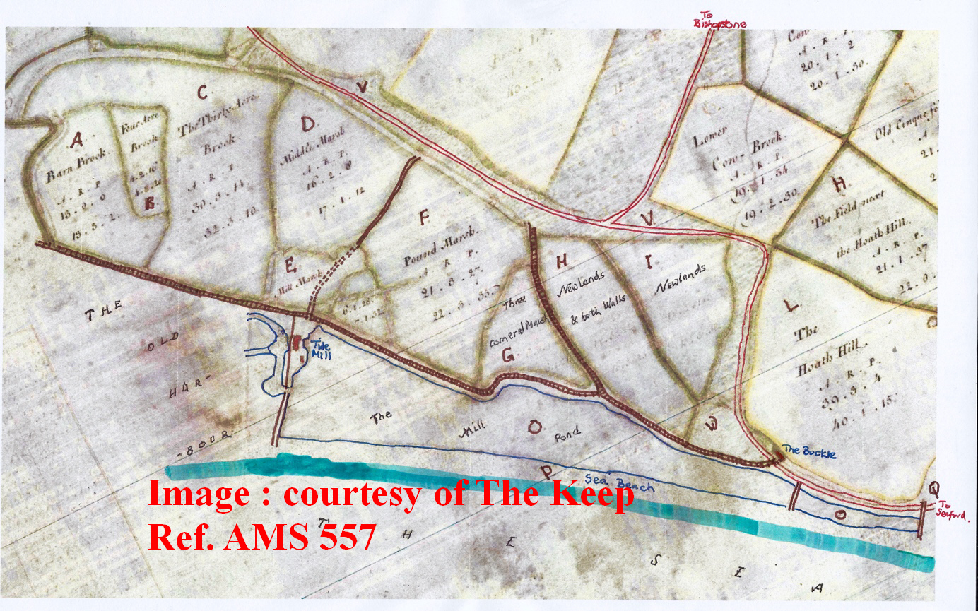
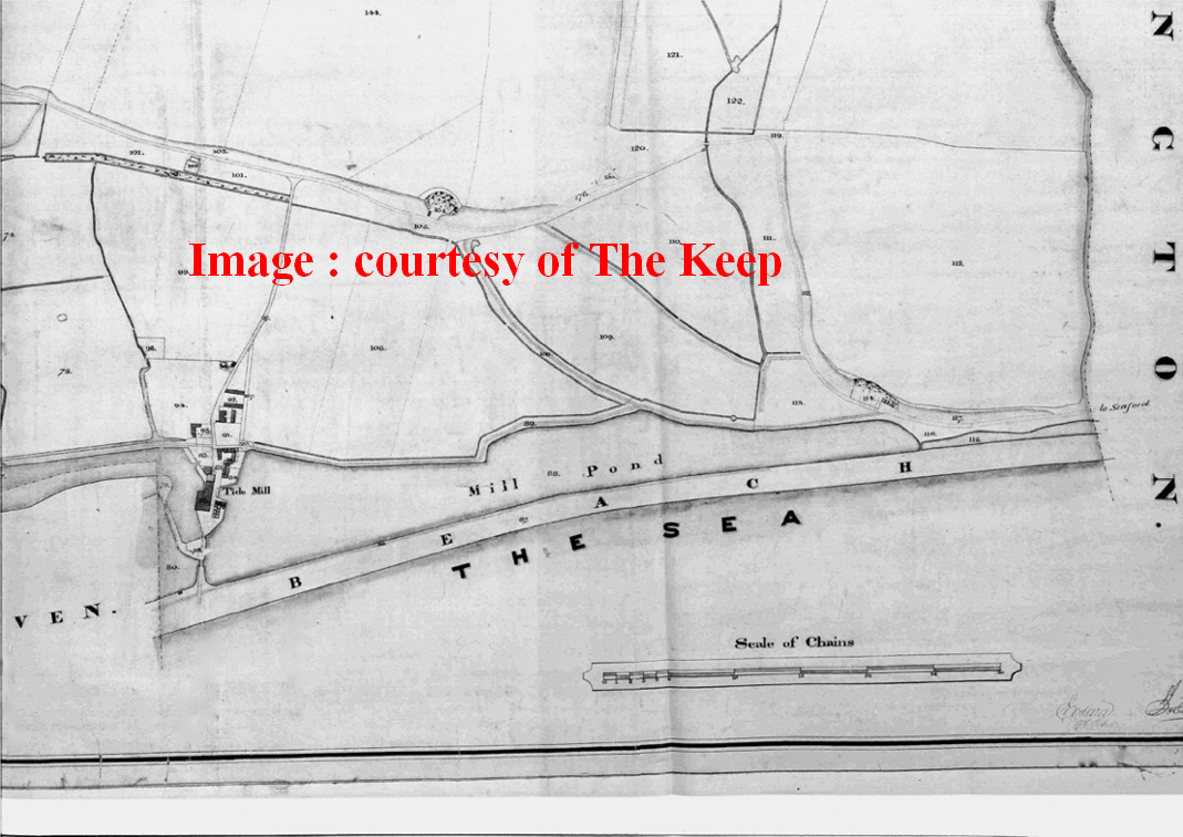
3. Tidemills - the early years 1761-1807 In 18th Century Britain, wheat prices increased significantly, partly as a result of the Seven Years' War, from a range of 26-35 shillings per Winchester quarter in the period 1745-1755, to 28-56 shillings in the following period up to 1767 and rose steadily after that (Nicholas Poynder, 1999). This ensured that there would be encouragement to British farmers to continue to grow this staple crop, as long as imports of cheap grain could be controlled. In 1760, The Society for the Encouragement of Arts, Manufactures & Commerce in The Universal Magazine announced a competition with a prize of £60 (£12,000 in today's values) to produce "the best model of a tide-mill by the first Tuesday in April 1761". Despite the Seven Years' War continuing, in this atmosphere of invention, Tidemills was created on Lady Day (25 March) 1761 through a private Act of Parliament sponsored by the landowner, the Duke of Newcastle, who was at that time on his second term as Prime Minister (1757-1762). It is clear that the parties to the Tidemills project meant business, as the engineering works involved substantial long-term private investment. For the 3 corn merchants, John Challen, John and William Woods, they now controlled a greater part of their process chain. For the Duke of Newcastle, he granted a 500-year lease from 25th July 1761 (The Keep, ESRO, 1853). It is fair to assume that he also judged that the reclaimed land behind the new structures would increase the value of this part of his Bishopstone holding. He also was willing to facilitate the construction process, by enabling the builder to carry out major quarrying work on the seaward end of his estate at Hawth Hill. This provided landfill for raising the land, both to enclose the new mill ponds and to site the buildings above flood level. The extent of lands in this lease is described in the Bill as "extending from the Mark Post erected at the East End of the Manor of Meeking", otherwise Newhaven, to the easternmost part of the Manor of Bishopston next to Bletchington Marsh, (i.e. Valley Dip) and abutting on the sea wall or mound against Bishopston Marsh, and the road leading from Bishopston to Seaford, towards the north and on the shingle or stonebeach against the sea, towards the south, (my emphasis) and the use of the water flowing and reflowing over the said ground, creek or channel. I emphasise the phrase relating to the stone beach as it clearly envisaged the smaller millpond built on it. This would be a challenging piece of engineering to withstand the battering it would get from the sea. It further gives rights over "a creek or channel of water passing through or lying in the said salt marsh, or waste ground, comprised in the said lease, which extends from a dock wharf and warehouse erected and built at the east end of the said marsh or waste ground, at a distance of about 1 mile from the town of Seaford, to the west part of the same ground where it runs into or communicates with a creek or channel called Old Haven Creek, and which also communicates with the River (Ouse) running from Lewes to Newhaven, and which creek or channel is navigable for boats or barges at Spring tides only". It is possible that this "dock wharf and warehouse" is the building appearing on Fig 4 at the far right of the image, but there is no other record of it. "Old Haven Creek" is clearly "The Old Harbour" in Fig 6. The poor state of the River Ouse is clearly problematic, so that seaborne traffic could only get to the mill at high tide.
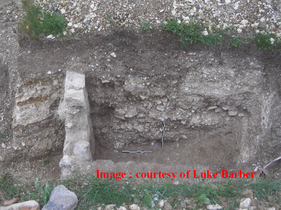
In Fig 6 therefore, Middle Marsh (plot D), Mill Marsh (plot E), the Mill compound, the 2 mill ponds (plots O), and the foreshore of Hawth Hill are included in the conveyance in 1761.This meant that the Duke of Newcastle retained the benefit arising from the reclamation, of the maximum area of land north of this lease, and shows that the second mill pond is an essential requirement to provide sufficient capacity until plans arose for enlargement of the mill. Over time, William Catt has to negotiate with the Earl of Sheffield as the capacity of the East Pond diminished, and he needed significant additional mill pond capacity for his expansion plans. 4. The 5 components of the first mill in 1761 a) The "island" and causeway on which the Tidemill structures were built. It is clear from the earlier survey maps (Figs 2-5) that the Tidemills venture was to be sited on level salt marsh with very mobile drainage arrangements over the previous 2 centuries. Tidemills as described in the Act of Parliament of 1761 could only justify its investment (in 1791 it was worth nearly £500,000 in today's money), if there was an infrastructure of a greater robustness than that which had gone before, in terms of land reclamation measures. Shifting creeks and streams off the Ouse had to be harnessed using new techniques to achieve a solution that which, up to now had proved fruitless when exposed to potent, daily fluvial and marine processes. The solution was to import significant volumes of landfill to supplement the shingle that would be excavated through the engineering works. This, as will be seen in c) below, came from Hawth Hill. One finding of Luke Barber's archaeological research is of particular interest. The curving north bank of Mill Creek where it turns south across the face of the mill is reinforced with mortar-bedded stonework encased by contemporary chalk landfill forming a reinforced bank just where the coal wharf was sited (Fig. 7). Luke Barber reports that chalk was indeed extensively used to bring up the levels for the buildings on site. Most of the chalk layers were not more than 400mm thick. The deepest level of infill (excluding the wharf reclamation) was seen under the coal yard(originally the wharf where corn was unloaded) - but that was dumps of alluvium, shingle etc. All round the site the excavations hit 'alluvium' at a relatively shallow level, but it is difficult to distinguish between what is in-situ alluvium and what is recycled alluvium, required to build up levels. I think certainly some of the building-up will be using alluvium/clay rather than just chalk. These islands had to be protected from the twice-daily scour of the mill stream. A photo of the mill taken late in its life shows the eastern face of the island wall abutting the East Mill Pond to be constructed with stone rubble also to a significant height. Another photo of the Mill Creek embankment beside the coal yard wharf shows reinforcement with large-section timber piles. I conclude that where stone reinforcement was required, it was used. This is important in my speculation about construction of the smaller easternmost mill pond.
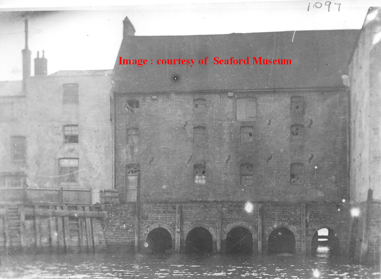
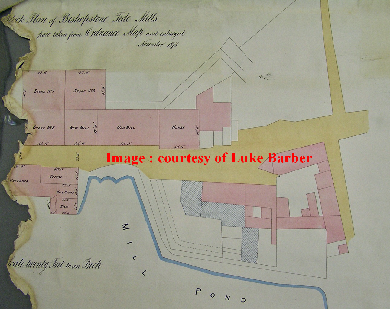
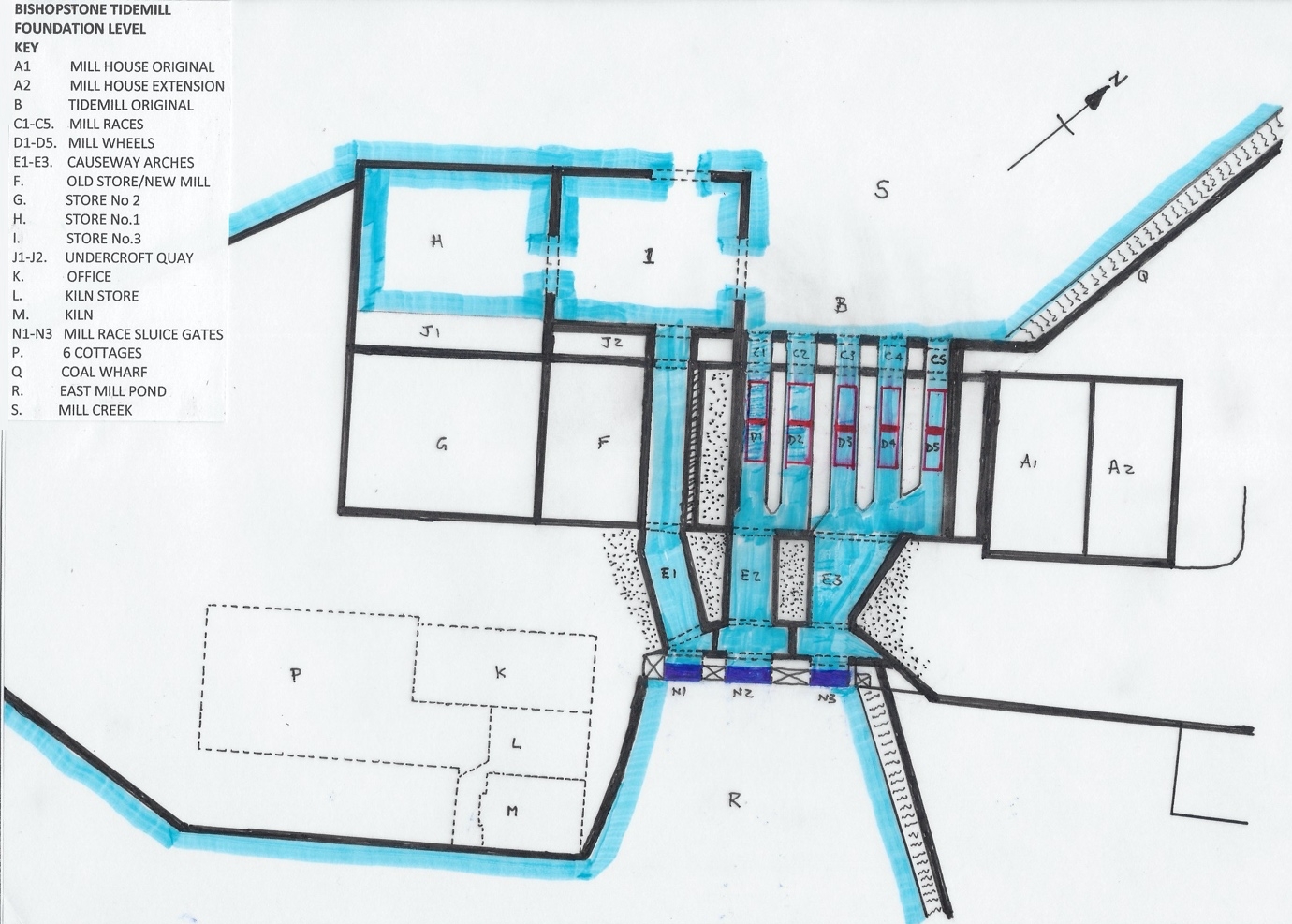
The 2 islands were separated by the mill race and linked by a brick 3-arched bridge/causeway which served as the main street. The faces of the arches of the causeway have been much altered over time, by being reduced, refaced with new brickwork or cement, or even filled in, but it is nevertheless possible to see that the western facade of the causeway has a regular pattern of 2 rows of original brick arches forming the original voussoirs, 2 of which are under the old mill (see Fig 21 and building B in the appendix) and 1 of which is under the "new" mill (see Fig 21 and building F in the appendix). Two of these arches (E2 & E3 in Appendix) provided the entry point for the 5 mill races within the original mill. It will be noted that E2 & E3 are of different widths, as E2 drove wheels D1 & D2, and E3 drove wheels D3,D4 & D5. The 3rd arch E1 bypasses the old mill. It appears to be a means of filling the eastern millpond on a rising tide, supplementing the sluice gate further south. It would therefore provide backup in the event that southern sluice gate failed. All 3 arches would have had rising gates on their eastern facade, although these were replaced by a new timber structure that spanned the stream as N1-N3. This new structure appears for the first time in the Bishopstone Tithe map of 1841(Fig 19) but was absent in William Figg's survey of 1824(Fig 18). b) The mill was a 3-storey building, 98 feet long by 37 feet deep, (10,878 square feet floorspace) with a clay tile roof with 2 elements separated by a party wall that pierced the roof (see Fig 23) The larger element, 64 feet long, (see Fig. 21 below) 7,104 square feet (660 sq. metres) of floorspace was the mill containing 5 undershot wheels driving 5 pairs of stones. The ground floor enclosed the top half of the wheels, the first, or stone floor, had the 5 pairs of millstones, and the second, or bin floor, had the chutes that fed the millwheels. The second, smaller element, 34 feet long, (3,774 square feet) was the storehouse for the wheat and flour, separated by the brick party wall to provide fire protection. Abutting the western facade of the brick causeway, the mill was supported on its eastern side by the 3 causeway arches, and on the western side by an undercroft with 5 arches each 6 feet wide. The mill was constructed wholly on piled foundations and Fig 22 shows that the undercroft structure of the mill section was subdivided into 4 "cells". The cell nearest the Mill house was infilled as it was not required for a water wheel, as it had the Mill ground floor entrance door above it. The next 2 cells related to mill races C1/C2 and C3/C4/C5. The floor to ceiling height of the ground floor was 10 feet(3.1m). The final cell was the space between mill race C1 and the party wall. I assume that the axles for the undershot wheels were within the undercroft but close to floor joist height, so the wheels were of the order of 12-18 feet maximum in diameter. The wheels were as wide as the races, i.e., 6 feet. The sale details of 1791 set out in Section 5 below refer to 5 pairs of millstones, relating to the 5 wheels. The water from the east millpond entered the undercroft through causeway arches E2 & E3, turning the 5 vertical undershot wheels, providing the driving power for the 5 pairs of millstones on the first floor above. The water then exited into Mill Creek out of the 5 arches. The cycle of operation therefore was for the rising tide to fill the East Mill Pond, both through the southern sluice and through arch E1, until high tide was reached. The southern sluice and E1 gate were then closed, and the mill race sluices for E2 & E3 were then left sufficiently open
at their bases for the head of water to exit via the 5 mill races on the falling tide, until the mill pond was empty. The undercroft of the storehouse element was not sub-divided, apart from the tunnel E1. It is conjecture as to what the western facade of this building looked like, but it is likely to have elements shown on this facade in the 1900 photo, i.e., a series of vertical windows and loading doors and gantries, and a ground floor doorway onto the timber wharf. The undercroft facade was the arch for E1 and the rest was solid brickwork (see Fig 22). This extension of the feature above arches C1 to C5 enabled barges to load and unload via doors and gantries, directly into the 3 floors of the store. This is the certainly the pattern with the facade of the later 1824 extension. It would also allow coal deliveries to be handled on a different wharf completely separate from wheat/flour cargo handling. This feature was preserved when the new 3 storehouses G,H & I, were constructed.
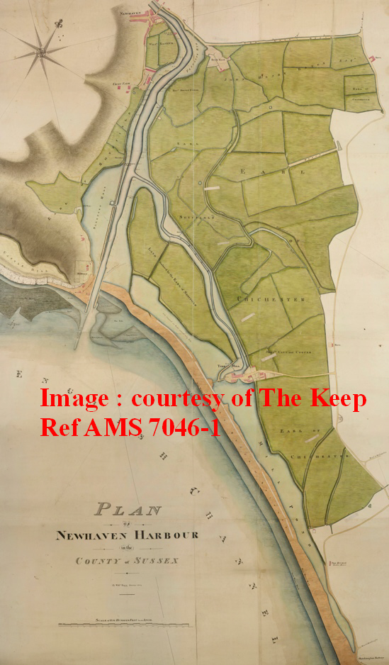
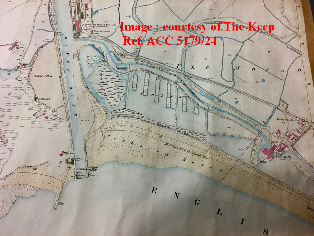
The only connection with Newhaven from this quayside was a "bac pour passer la riviere, ou y peut passer au gue quand les eaux sont bassee (ferry to cross river where it is possible to ford at low tide) marked with a "D" on the map. John H Farrant MA (Farrant J. H., 1976) suggests that the corn trade was kick-started by this tidemill, creating a significant demand for about 1.5 tons of corn a week (see Section 5 below for more details). The Duke of Newcastle commissioned Thomas Marchant to survey his Bishopstone and Norton farms in 1777, and this gives the full picture of the mill construction (Fig. 6).
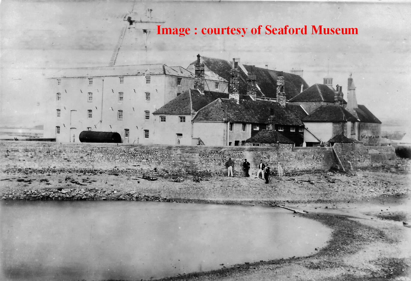
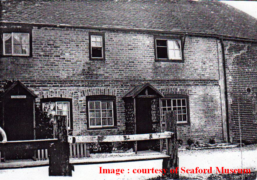
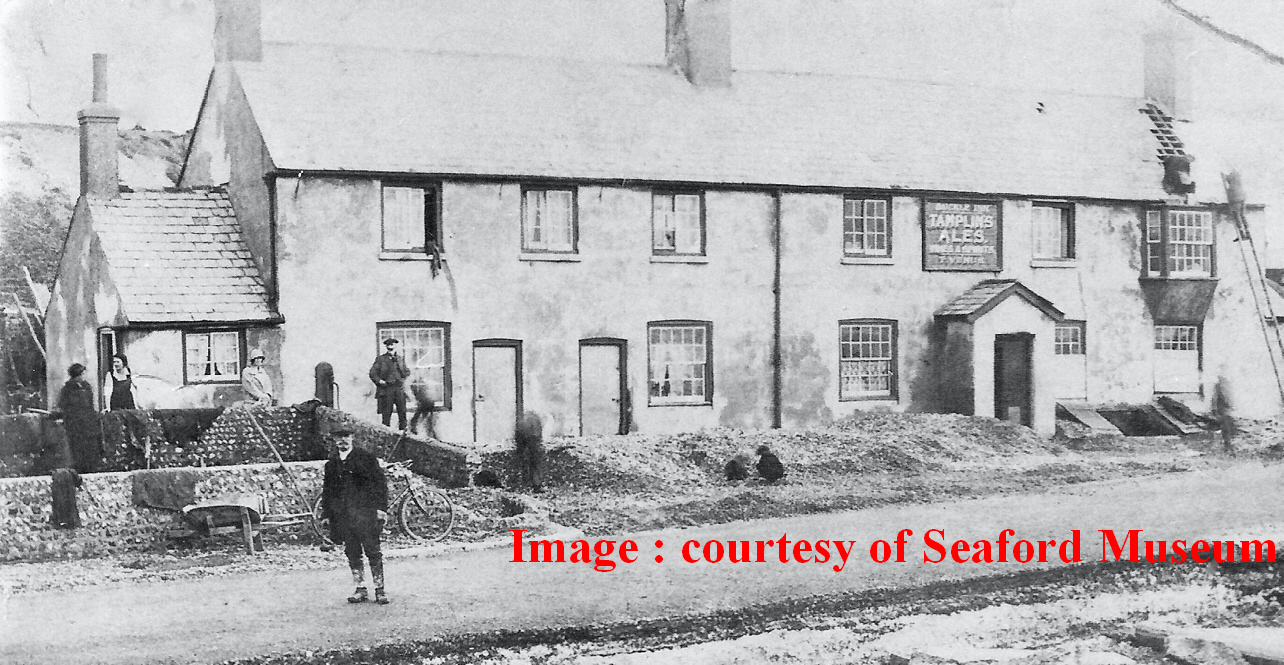
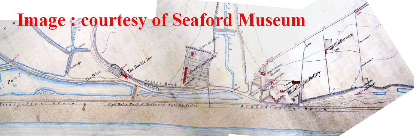
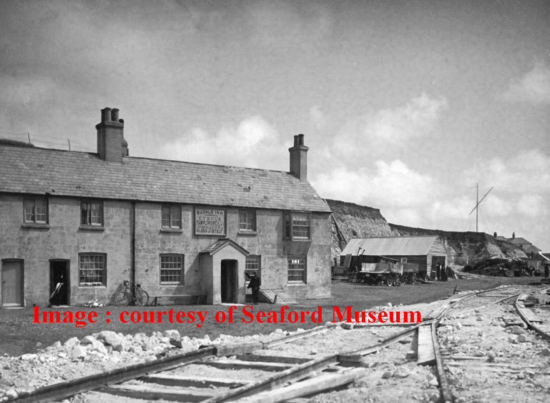
c) Adjacent to the mill was a 'small neat mill-house'. Looking at the architecture, and the roof structure in 1918 aerial photos, I have concluded it was attached to the old mill building because of Thomas Marchant's survey of 1777 where it shows a continuous building. The house had a different architectural style to the mill with classical hints. The roof structure has a saw-tooth profile roof structure with three exposed gable ends. In addition, Fig 6, shows a small group of cottages built on the island for the mill-workers together with 4 cottages on a ledge at the seaward side of Hawth Hill. Fig. 11 & Fig 12 show both have unusual sliding windows on the first floor. Although the Buckle cottages have sash windows on the ground floor in 1924 when the photo was taken, it is possible that, given the exposed position of the Buckle cottages, the original ground floor windows could have been replaced. Both groups of cottages have arched window heads and both are constructed in brick. There is a footpath from the Buckle cottages along the north retaining wall of the mill pond westwards to the Tidemill, reinforcing the theory that both groups formed the nucleus of housing for mill workers. Given the unsocial hours of working because of the ever-changing time when high tide happened, workers' accommodation was an essential part of the mill's operation. The 1841 census shows that mill workers and a bargeman lived in the Buckle cottages. It is not known when the Buckle Inn started as a pub in the easternmost cottage. It was a pub in the 1841 Tithe map. The Buckle cottages were owned by the Pelham-Holles family until 1807 (see text below). There is no document that sets out how much quarrying was undertaken to provide the material for the island and the retaining embankments for the mill pond, and the trackway now called Mill Drove, but we can be certain that one result of quarrying the cliff face was the creation of the Buckle ledge, 7m above sea level, with a 10-11m high vertical chalk face behind it. The 1761 Buckle ledge 7m above the beach was about 30m from front to back from the assumed 1777 cliff face back to Buckle Bank. The fields above the platform are around 17m above sea level. Thus, an average depth of 10m of material had to be removed to get down to the Buckle ledge. I calculate that
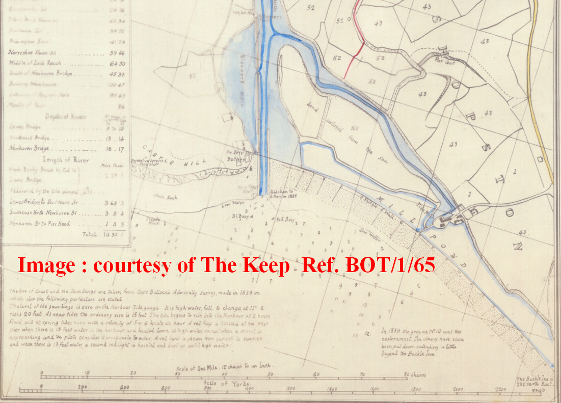
approximately 100,000 cubic metres of material was quarried to help form the new Tidemills infrastructure. I believe a further justification for the creation of the Buckle ledge was to create a more manageable route from the east side of the Ouse valley into Seaford. Up to that point, the Richard Budgen map of Sussex (Fig.13) shows the old route from Newhaven to Eastbourne via Seaford marked by milestones with Milestone 12 at Denton, through to milestone 6 at Exceat Bridge. This route had to negotiate the steep drop from Denton into Bishopstone and then up to East Blatchington, passing through the Duke of Newcastle's estate. The new Buckle ledge allowed the 1761 Buckle road to avoid these slopes via Bishopstone, because the road now followed the valley edge via the Buckle Inn, and on via what was to eventually become Claremont Road, into Seaford. e) The East mill pond had 2 clear elements both marked "O"' in the 1777 survey (Fig 6), i) the large east mill pond, sitting on the former saltmarsh between Tidemills and Hawth Hill and ii) a smaller narrower, westward-draining mill pond at beach level below the Buckle ledge, which also served to drain what was then called "The Salts" now known as the Old Brickfield or Valley Dip (see Figs 1 & 6). It included 2 sluices, two bridges and a levee on the seaward side to provide protection for the pond and its enclosing structures from the sea. There is no evidence as to how this smaller mill pond was constructed, but as the feature lasted from 1766 until at least 1864, (Figs 6 & 14) it must have been built on the underlying chalk platform (Fig 15 & 16) in front of Hawth Hill and have been robust enough, when sheltered by a rampart of shingle excavated from within the new mill pond, to withstand the marine forces that assault this part of the coastline. I do not think a simple shingle embankment would a) have the slender cross-section shown in Fig 14 nor b) be robust enough to protect this important source of energy to operate the mill from the ravages of the sea. We know there were significant storms that damaged the mill infrastructure in 1785, 1792, 1824 and 1855, in addition to 4 severe ones after that period. This chalk ledge is typical of the entire stretch of chalk cliffs from Brighton to Beachy Head and was exposed at low tide. Fig 16 shows the base of the platform at the cliff foot.
5. Tidemills - the first 46 years 1761-1807 After 1761, the mill ownership went through several hands in fairly quick succession for unexplained reasons. The Keep has a series of documents (ref ACC 4299/2/1/7/1) covering William Catt's estate when he died in 1853 and this lists various assignments of title during this early period, namely, a) an assignment of John Challen's interest on 24 June 1772 to Mr Thomas Rickman, b) an assignment of Thomas Rickman's interest to John Woods on 3 May 1777, by which means John Wood consolidated his ownership. Tidemills was put on the market on 19 September 1791 (Lyndhurst, 2001, revised 2008), and at that time it was described as "a newly built tide corn mill . . .(with) 5 pairs of stones and the mill is capable of grinding on average, about 140 quarters (just over 1.5 tons) of wheat a week. Adjoining the mill is a small neat dwelling house also a coal wharf, from which an increasing trade is carrying on; vessels of 100-140 tons load and unload at the mill and the situation is well adapted for an extensive coasting of foreign trade in corn and flour" (Farrant S. , 1975, p. 200) It was purchased from John Woods in 1791 for £3,000 (£429,000 in 2018) by Thomas Barton of Lamberhurst. There were several recorded attempts to protect the mill infrastructure and these will be described later in this article. There was a violent storm in 1792 that destroyed large quantities of flour and wheat at the tidemill. (Smith, 1997, p. 39). The 1795 survey of the Ouse by an unnamed surveyor (Fig.13) is technically poor in a number of respects, but it does seem that the 2 east mill ponds have diminished in capacity and therefore capability, possibly because of shingle encroachment on its seaward defences. On 1 November 1798, Thomas Barton assigned his interest to John Farncombe, with a mortgage of £2,000 (£238,000 in 2018), so unless Farncombe invested assets of his own to supplement the mortgage, it had lost significant value over the passing years. On 23 October 1801, the asset was assigned to Edmund Catt, who passed it on to his cousin, William Catt,
and to Edmund Cooper, on 9 October 1807. William and Edmund finally got the freehold on 4 August 1820. The Buckle went through a separate ownership route before ending up in William Catt's hands on 24 June 1828, having been previously in the hands of the Earl of Chichester until 5 November 1807 when it was leased to John Mr John Gorring until he sold it in 1828. 6. Tidemills - the era of William Catt 1807-1853 William Catt (1776-1853) was an energetic entrepreneur, and during his ownership (1807-1853) the mill expanded significantly (see the 2 cover illustrations for details). Firstly, there was a continuing need to maintain the beach/embankment, which had eroded the capacity of the East Millpond. Next, William wanted to enlarge the mill. This would require an increase in stored water, and so on 11 March 1814, William Catt and Edmund Cooper entered into an agreement with the 1st Earl of Sheffield to lease and embank marshland to the west of the mill, creating the West Mill Pond (The Keep, ESRO, 1853). This was enlarged by a further lease dated 3 June 1816 (The Keep, ESRO, 1853). It is not clear where the material came from to embank the new West Mill Pond, but much must have come from the West Mill Pond site itself. I reach this conclusion because I cannot find any contemporary records like the 1899 agreement for enlarging the Buckle ledge. Indeed, such an arrangement would have involved the 4th Duke of Newcastle, and agreement may not have been forthcoming. Also, a comparison of the width of the Buckle ledge in 1777 (Fig.6) with that of 1841 (Fig.15) shows little difference. William Catt purchased the freehold of his Tidemills lease from the Earl of Chichester in 1820. This consolidation of his asset would have enabled him to invest significantly in enlarging the mill complex. Edmund Cooper ceased to be included in leases after 1826. New leases from the Earl of Sheffield regarding this marsh land, i.e. on 15 March 1830, 12 November 1835, 9 November 1841, and 13 November 1844, all are solely with William Catt as is the purchase of the Buckle. William Catt's grand ambitions were realised when I believe he converted the mill store (Building F) into a new mill which got its drive for the new millstones via shafts connected to the old mill wheels and passing through the party wall. The new extension (Buildings G,H & I) was of 4 storeys of 16,380 sq.ft. (1,522sq.m.) and increased the floor area of the mill enterprise by 150%. It had to use totally different construction methods, as the area occupied by Store Rooms 1 & 3 was built on piled foundations in the mill creek. Whereas Store 2 (Building G) appears to have no undercroft as it was built on the island infill. Stores 1 & 3 incorporated an internal loading bay for barges to load and unload under cover. This loading bay probably used the old door openings and gantries of the original building to which it was attached with appropriately placed trapdoors in the floors.
The construction of the West Mill Pond required a new sluice entry point for the incoming tide to enter West Pond, and pass through to East Pond via a new, more southerly sluice. Whilst maintaining the simplicity of flow, it did make the mill more vulnerable to marine erosion. This is illustrated in the most contemporary survey of 1824 (Fig 18). However, it is not clear how successful this West Millpond was, as on 23 November 1824 a great storm hit Seaford Bay, with Seaford Beamelands being inundated, and boats being swept up inland as far as Bishopstone. In the 1838 Newhaven Tithe map the site is called Brookland rather than Mill Pond (as in the 1841 Bishopstone Tithe Map (Fig 19 above), indicating that it was of marginal use at that time as a reservoir to feed the mill-races.
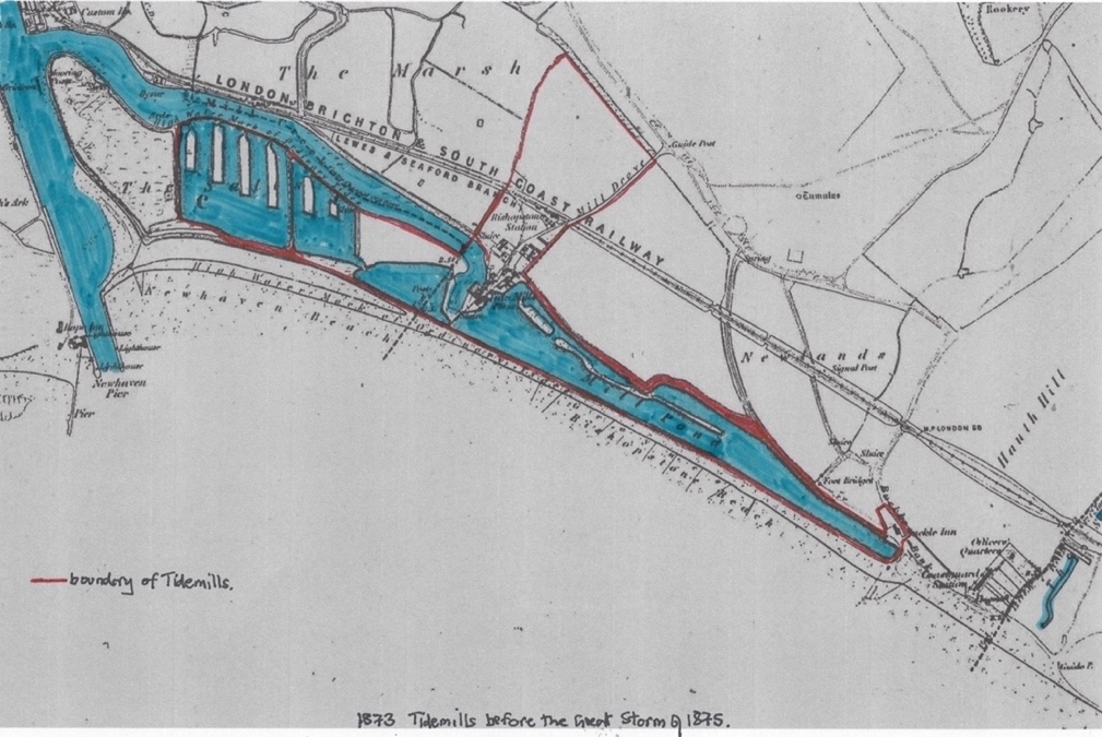
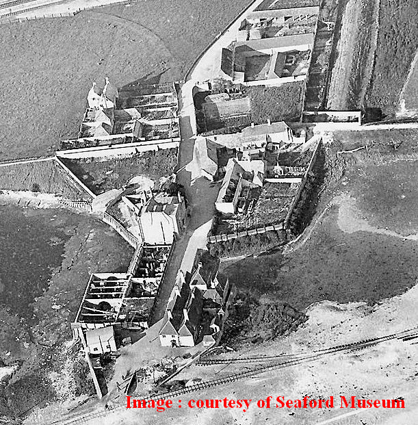
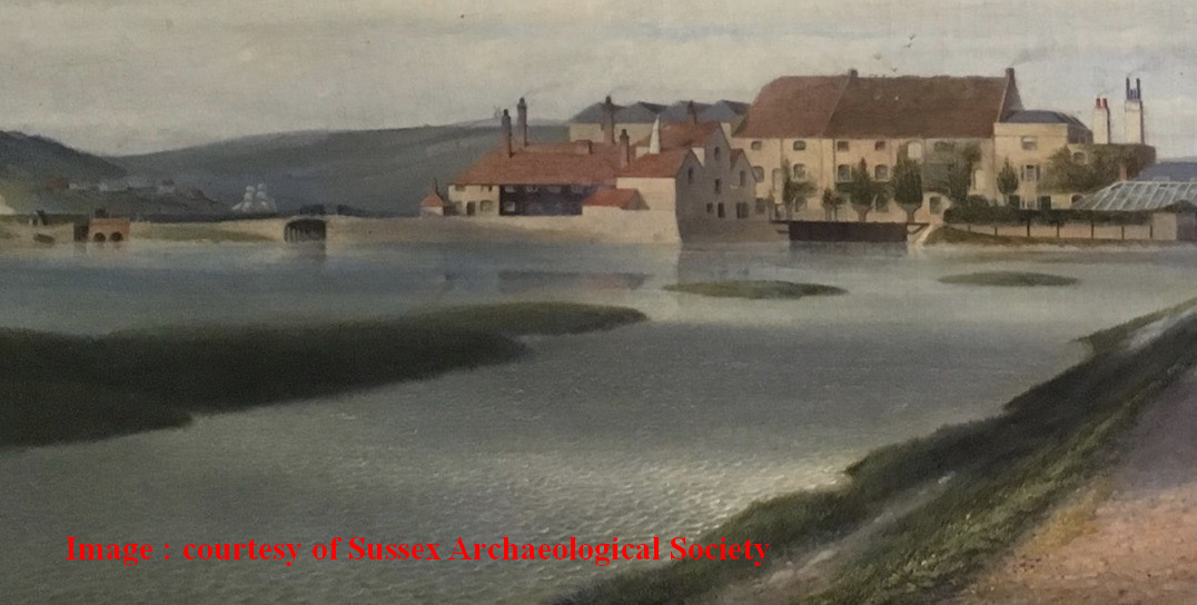
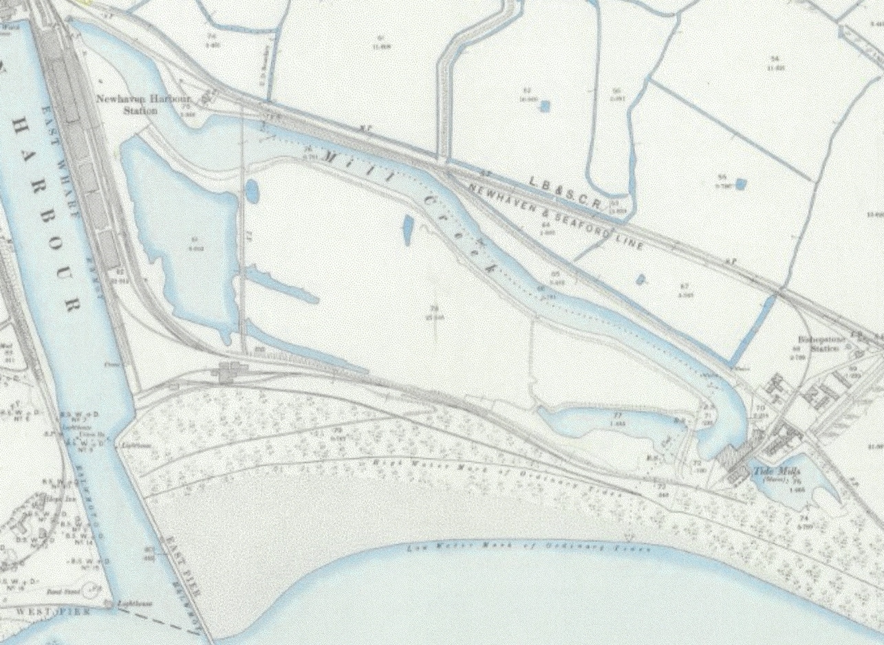
7. Tidemills - the last flowering 1853-1875 After William Catt's death on 4 March 1853, his son George (1813-1878) continued his father's work by installing the smock mill around 1862, above building H, to assist in hauling sacks within the mill building, particularly from the undercroft quayside. This became a very distinctive part of the silhouette of the establishment. It may have been this extra loading on the building that meant that 'S' shaped pattress plates appeared at regular intervals at each floor joist level on each facade to stabilise the structure. The 1861 census describes George Catt as 'employing 40 men and 3 lads' so it was still a major enterprise. George also tackled the problematic West Mill Pond around 1864. This appears to be a joint venture with the Commissioners of Sewers, as a plan proposal was carried out for the Commissioners by William Figg (Fig. 24). In addition, the London, Brighton & South Coast Railway Company posted plans to extend their network from Newhaven Wharf station to Seaford and this was done by 1 June 1864. It is suggested that George Catt actually invested money in the railway (Vince, 2015, p. 11), and certainly a siding from the main line onto the Tidemills site was constructed, featured on the 1864 William Figg survey (Fig.24). A cottage built in 1830 on the field numbered 94 in Fig. 19 became the stationmaster's house. Further protection for both
mill ponds had to be provided on the beach side, because of the occasional storm damage, such as that in 1820 which damaged the mill building, and washed away some of the mill dam. (Smith, 1997, pp. p39-40). So a series of 20 groynes were constructed between 1824 and 1842, and further 10 were added just beyond the Buckle Inn in 1869/70. The small east mill pond disappears from the next major OS survey of 1872 (published 1875) Fig 25. The circumstances of its gradual disappearance are documented in a number of newspaper articles of the time. 25 October 1855 Report held by Newhaven Museum Book 13 Newhaven harbour and River Ouse. "On the night of 25th October 1855 a storm raged here which for violence has not been equalled for many years. At dawn on the 26th it was discovered that the embankment between the East Pier and the Tidemills had been breached by the sea. These anticipations were painfully realised. On came the tide, the waves frequently rushing and dashing over the piers, so as to render it dangerous to venture on them. Many months will elapse before the damage can be repaired , an enormous expense must be incurred by Messrs. Catt can again raise the barrier between the ponds and the sea".
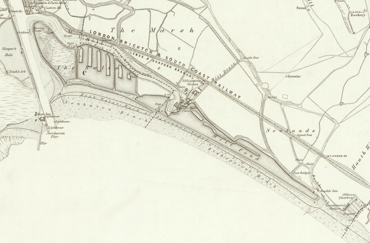
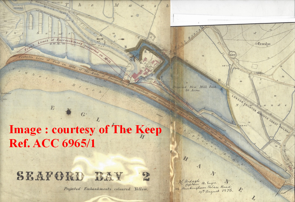
Sussex Advertiser Tuesday 8 November 1859 "SEAFORD. On the morning of Tuesday, the 1st inst., this town was visited by a severe storm of rain and wind, accompanied by lightning and thunder, which continued throughout the day. About six in the evening it increased to a heavy gale Long before high tide the sea broke over the lower and weaker parts of the beach, and the green in front of the town was speedily covered with water, which continued to flow up to the New Inn. Much damage has been done to the battery wall facing the sea in which there are several large fissures, owing to the force of the tide having undermined the foundation, which caused the wall to sink from its own weight. The boat house upon the beach was completely destroyed, and much damage has been done to the tower. The road facing Blatchington battery has been entirely washed away and a great part of the battery was washed down by the force of the waves". 8 November 1859 (Note held at Seaford Museum MFN 13351) "Storm - flooded New Inn. Battery wall collapses, much damage done to the Tower. The road facing Blatchington Battery entirely wasted away with a great part of the battery". 28 October 1862 (Note in Seaford Museum records ref MFN 13352) "There was a grand sight here. Just noon at high water. The sea was coming right over the bank, the road was flooded and a beautiful cascade of water was falling over the road into the valley between the coastguard station and Blatchington Battery". These were not the first storms to batter the coast, but with previous events, this easternmost mill pond was an integral and necessary part of the millpond capacity required to drive the water wheels. By 1830 the added capacity of the West Mill Pond made the smaller eastern millpond almost redundant, and so I suspect George Catt thought it was an unnecessary expense to keep it going and allowed it to decay. Thus, although the western boundary of the eastern millpond appears sharp in Fig 14, it will be noticed that it is open at the eastern end and clearly at the time of the survey (1860/61) it was already beginning to become choked with shingle such that it was dry at low tide. The storms would clearly have exacerbated this situation so that by the time the photos in Fig 15 were taken the effects of the intervening storm damage had eliminated this mill pond. 8. The Great Storm and the growth of Newhaven Harbour 1875-1883 Two factors sounded the death-knell of the Tidemill, i) the force of Nature, and ii) the economic regeneration of Newhaven Harbour. i) Nature took a further cruel turn on 14 November 1875, when a combination of high tides and strong winds breached the beach from Castle Hill to Splash Point causing immense damage. This was far stronger than earlier ones, causing the overwhelming of the 2 remaining Mill Pond retaining walls, rendering the Tide Mill powerless, and heavily damaged. It is clear that the shape of the east mill pond changed significantly between the survey for the Tithe Map (Fig. 19) and the 1875 OS map (Fig. 25) which shows a sinuous shingle structure on the north side of the East Millpond which is within the boundary of the original conFiguration. The records do not explain its
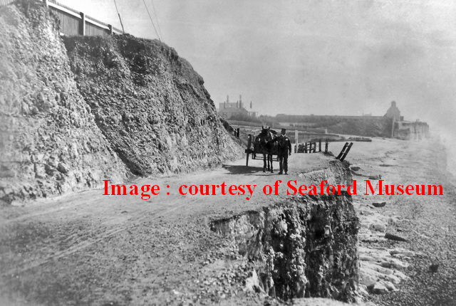
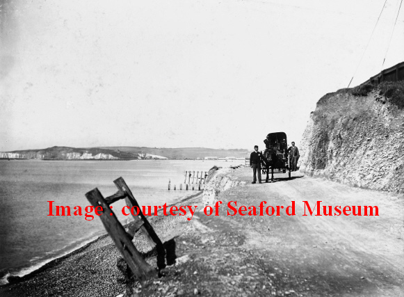
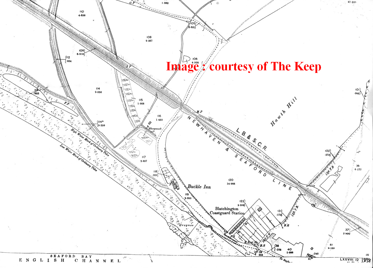
purpose or structure. It was surveyed up to 1878 and therefore reflects the damage caused by the series of earlier storms. The 2018 Google Earth photo (Fig 1) shows that the current footpath that runs along the northern boundary of the millpond depression runs along the line of this sinuous shingle structure, NOT along the original bank. The ground immediately to the north of this modern footpath is botanically of a different nature to the rest of this field between the footpath and the railway, and there is a land drain that defines the edge between these 2 areas of Bishopstone Tithe map that this field was owned by the Earl of Chichester and farmed by George Farncombe, and so was not part of Catt's Tidemills operation. The Commissioners appointed Capt. James Ardagh to report on how to restore the operation of the Tidemill and repair the wider damage, and he reported on 17 August 1876. His accompanying plan demonstrates the destruction caused to the estuary (Fig. 26). His solution was to create an entirely new channel north of the Tidemill complex, together with a new East Mill Pond covering 20 acres, south of the railway embankment. No immediate action could be taken as a further storm on 6 January 1877 was reported to have "submerged the railway, and the road and from Newhaven to the Buckle; also the whole of Mr Catt's land at Bishopstone, the principal part of Mr Farncombe's land, south of the main road leading from Newhaven to Seaford. The land between the Buckle bank and Blatchington Battery was entirely under water, some 10 feet deep. The sea wall from Bishopstone mills to the Buckle, for upwards a mile in length, is now nearly total wreck, only a few mounds being left of it, with large gaps between". This was just a small part of the coastal damage done in the storm, and Seaford people claimed more immediate attention (the new sea wall from Splash Point to Pelham Road was started in May 1881 and completed by November 1882), so George Catt started legal proceedings against the Commissioners seeking repayment for the money he had to spend repairing the sea defences that had been breached. The case was not settled before he died on 10 April 1878, probably prematurely, as he passed away in London at the Gloucester Road Underground station of the Metropolitan line, aged 65, leaving an estate worth £34,197 4s 8d, (£3.8m in 2018), probate being settled finally on 20 May 1886. There were clearly complications, as attempts to settle probate in 1878 and 1880 failed. His widow, Emily was left to settle all these loose ends, and on 25 January 1879 accepted settlement of the damages at £1,200, and on 29 September 1879 sold the Tidemills operation to the Newhaven Harbour Company for £11,000 (£1.3m in 2018). ii) Newhaven Harbour was being rejuvenated at this time under the terms of the Newhaven Harbour Improvement Act 1878 which got Royal Assent on 17 June 1878, and so the Trustees of the Newhaven Harbour and Ouse Lower Navigation transferred their interests to the newly-formed Newhaven Harbour Company which was largely under the control of the London Brighton & South Coast Railway. John Catt (George's younger brother who changed his surname to Willett) and Edgar Stoneham took out a 14-year lease on the mill from the Company on 29 September 1879, but the Company bought back the lease 4 years later for £3,000 as they tried to find a new use for the site as a cement works, but these negotiations with the Portland Cement Company foundered in 1884. 9. Tidemills under new management 1883 to date The works during the 1880s to develop the East Wharf of the harbour had interrupted the flow of mill creek, which was now regulated by a sluice rather than free tidal flow. By then the smock mill had blown down in a gale, severely damaging the granary as she fell. The west mill ponds were filled in with chalk from Brighton College brought in via the new tramways that were created by the Newhaven Harbour Company which was expanding with new gothic buildings built between 1883-7 and needed to dispose of the landfill. (Lyndhurst, 2001, revised 2008, p. p30). The OS revisions of 1893-8, 25-inch series (sheet 78.7) (Fig 28) show these tramways extending from Newhaven Harbour station onto the beach above ordinary high tide across lands that had clearly been restored at least in volume and extent, until bigger sea defence work could be implemented. The tramways ran on track bed that covered the 2 sluices from Mill Creek and the western Mill Pond because they served the new use for the Mill buildings as a bonded warehouse. Thus with this work and the sluice at the junction of the River Ouse with Mill Creek, the tidal mill was dead. The decision to restore the beach defences was effected through an agreement for excavation chalk from Hawth Hill dated 7 June 1899 between the Earl of Chichester and The Commissioners the Newhaven and Seaford Sea Defence Works, setup by Act of Parliament in 1898. This completed the wall from Pelham Road to Tidemills, linking with sea defences carried out by L.B.S.C.R between Tidemills and the East Pier at Newhaven in the early 1880s. This fresh quarrying resulted in Buckle Bank retreating on average by 20m inland. This created enough spoil to reconstruct the beach from the Buckle to the eastern breakwater probably by using the quarried chalk as landfill above the high tide mark, and allowing the shingle it replaced there to be moved seawards to form a more effective barrier on the lower beach. The landfill was distributed by a rail system which also connected to the existing network from Newhaven Harbour station. This is recorded in a well-known photo held at Seaford Museum (Fig. 26) and remnants of these tracks can be seen even today. The railway embankment west of Tidemills served also as a part of the sea defences and remains to this day. The groynes were extended to Splash Point. In 1890 the main mill building was converted to a bonded warehouse, a use which lasted 10 years before the mill and warehouses were demolished, leaving the small village standing (Lyndhurst, 2001, revised 2008, pp. p 30-32). The Tidemills site had a varied life after the mill buildings were demolished, and this is well recorded elsewhere (Vince, 2015) (Lyndhurst, 2001, revised 2008) and so this paper does not seek to reproduce that account here. The superstructure of the mill buildings was demolished in 1901, and by 1937 when the survey for the 1938 OS map was done, even the undercroft structures had gone, and by January 1939,all the inhabitants were rehoused leaving the residual structures to be used by the Army for military training. By 1945 the site became as we see it today.
10. Conclusions The 1898 OS map (Fig 27) shows the transformation of the landscape to meet the Newhaven Port's requirement, its former use fading away, a sad end to a daring experiment that was remarkable for tapping into "green" energy, more than 200 years before such concepts became essential to the survival of this planet. I appreciate that my speculation about the construction of the small east mill pond may be controversial but it seems entirely consistent with the varied construction details used to create the Mill in the first place and to protect the massive investment it represented for over 100 years. Without reference to the historical development of Tidemills, it is difficult for visitors now to interpret the landscape on what is now the Tidemills Local Wildlife Site. It is important to recognise what a significant enterprise it was during its lifetime, bringing much more that a return on investment by a succession of private entrepreneurs. C.A.GRIMBLE 2021.05.09
11. TIDEMILLS TIMELINE
12. Bibliography (n.d.). Brandon, P. F. (1971). The origin of Newhaven and the drainage of the Lewes and Laughton Levels. Sussex Archaeological Collection, 94-106. Commons, J. o. (1762, 02 09). Corn. Bishopsten, Sussex. Tide mills. Petition of merchants for sanction to build tide mills for grinding corn. Retrieved from 18th century British Parliamentary Papers: http://www.bopcris.ac.uk/bop1688/ref624.html Farrant, J. H. (1972). The evolution of Newhaven Harbour and the lower Ouse before 1800. Sussex Archaeological Collection, 44-60. Farrant, J. H. (1976). The Seaborne Trade of Sussex 1720-1845. Sussex Archaeological Collections , 114, pp. 97-120. Farrant, S. (1975). Bishopstone Tidemills. Sussex Archaeological Collection, 199-202. Horsfield, T. W. (1835). An illustrative of the history, Antiquities, and topography of the County of Sussex. Lewes: J.Baxter. Lyndhurst, D. (2001, revised 2008). Bishopstone and the lost village of Tide Mills. Nicholas Poynder. (1999). Monthly grain prices in England1270-1955. Retrieved from International Institute of Social History: http://www.iisg.nl/hpw/poynder-england.php Smith, D. S. (1997). Watermills of Sussex Vol 1. Baron Birch. The Keep, ESRO. (1853). Schedule Title Deeds and writings relating to Bishopstone Mills. ESRO reference: ACC 4299/2/1/7/1. Uwe Dornbusch, D. (2018). GIS comparison of 1620 map with current satellite images. private work. Vince, R. (2015). Tidemills, a village ahead of its time. Seaford Museum Publications. APPENDIX
|
||||||||||||||||||||||||||||||||||||||||||||||||||||||||||||||||||||||||||||||||||||||||||||||||||||||||||||||||||||||||||||||||||||||||||||||||||||||||||||||||||||||||||||||||||||||||||||||||||||||||||||||